Monday, May 20, 2013

Lavender Fields, UK and France

Lavender Fields

Introduce:

Close your eyes and breathe deep - your senses tell you you are in Provence ! The Provence of lavender fields in bloom ! The heady scent of lavender is strongest in the heart of the summer, from mid-June to early August is when the fine stalks wave in the wind, blue prairies stretched as far as the eye can see. Lavender fields cover the high plateaux in the Sault area, at the base of Mont Ventoux. Lavender grows in the Apt area, in the Luberon and in the Valréas Enclave.

Lavender has traditionally been used to scent household linens and bath water.

The bees love lavender and produce a fine, subtle honey from lavender. Explore the use of lavender in gastronomy too...

Location :


Lake Retba, Senegal

Lake Retba

Introduce :

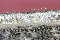
Having been at some point a child, you will certainly have dreamed of a lake made of strawberry milkshake. We can now reveal that it does exist. Okay, so it’s not exactly made of milkshake, but Senegal’s Lake Retba is certainly the right shade of pink.

Lake Retba’s amazing colouration derives from its high salt concentration — one and a half times higher than the Dead Sea. This makes it a prime habitat for halobacterium, a type of single-celled halophile (salt-loving) microorganism which is red or purple in colour. The water of lake actually changes from mauve to deep pink in colour, depending on the time of day and amount of sunlight.

Also known as Lac Rose (French is the official language of Senegal), the amazing pink lake is situated on the Cap Vert peninsula about 35km north of Dakar. That is the same Dakar of the Paris-Dakar rally, the mental Sahara desert motor race, for which Lake Retba is often the suitably amazing finishing point. In short, this place is generally a hive of extremophiles — halobacteria and high-octane racers alike.

For most of the year salt fishing is the major activity of the lake. Workers spend 10-12 hours a day in the water scraping salt from the lake bed, their skin rubbed with butter from the Shea nut to protect it from the inhospitable salinity of the water. Seen from above, with piles of white salt lining the shore, the lake appears as a pool of colour in a black and white landscape.

Location :


Sunday, May 19, 2013

Lake Hillier, Australia

Lake Hillier

Introduce:

Lake Hillier is a pink-colored lake on Middle Island, the largest of the islands and islets that make up the Recherche Archipelago, Western Australia. From above the lake appears a solid bubble gum pink. It is such a significant distinguishing feature of the archipelago that air passengers often crane their necks to take a glimpse of it.

The lake is about 600 meters long, and is surrounded by a rim of sand and a dense woodland of paperbark and eucalyptus trees. A narrow strip of sand dunes covered by vegetation separates it to the north from the Southern Ocean.

Location :

Antelope Canyon, USA

Antelope Canyon

Introduce :

The sprawling Navajo Nation has no shortage of magical places, but the most photogenic might be Upper and Lower Antelope Canyon, located just outside Page, Arizona. They are a testament to the power of water and time, as over the years, flash flooding has created deep, gorgeous passageways—called slot canyons—that you can walk through.

The name comes from an era when antelopes ran wild in the canyons, but the only animals you’ll see these days are other human beings. The 600-foot-long stretch of Upper Antelope Canyon, which is also known as the Corkscrew, is the more popular of the two canyons. The walls can reach 120 feet, and it’s easier to access; exploring the half-mile Lower Antelope—or the Crack—requires walking up and down metal stairways. Visitors to Upper Antelope are also more likely to see beams of sunlight, which are prized by photographers. (Slower snappers will want to know that there’s a two-hour limit in each canyon.)
As you might expect, both canyons have long been considered spiritual places by the Navajo. You may only visit with a guide—there’s a list at www.navajonationparks.org—although that’s as much because flooding remains a possibility, and rain doesn’t have to occur on the site for water to come rushing through the canyons.

While you’re in the area, check out Rainbow Bridge, a stunning 275-foot-tall rock bridge over man-made Lake Powell. It, too, is sacred to the Navajo, so in order to hike to it, you need a permit from Navajo Parks & Recreation.

Location :

Saturday, May 18, 2013

Shibazakura Flowers, Takinoue Park, Japan

Shibazakura Flowers


Intrduce :

The Shibazakura (Pink Moss) Festival is one of the most unique and colorful festivals on the Hokkaido flower calendar. Winding paths lead you across a surreal pink and purple hillside overlooking Takinoue town.

Every year from early May to early June, Takinoue Park is covered with a carpet of Shibazakura which started from the equivalent of a single tangerine box filled with seedlings. These flowers have spread and grown every year and now cover an area of 100,000 square meters.

The backside of the Daisetsuzan Mountain Range offers its pointy snow-covered peaks as a backdrop and tulips adorn the the wide gently-sloped paths on your journey across the hill.

A short distance to the right of the upper car-par you'll find food and drink stalls, playground equipment, tables and benches and a stage featuring music and dance performances.

All in all, this is a great place to spend a few hours and take some great photos before moving on to other sightseeing spots in the area.

Location :

Hang Son Doong, Vietnam

Hang Son Doong


Intrduce :

Son Doong cave(Vietnamese: Hang Son Doong) is world's largest cave, located in Quang Binh province, Vietnam. It is found by a local man named Ho Khanh in 1991 and was recently discovered in 2009 by British cavers, led by Howard Limbert. The name "Son Doong" cave means "mountain river cave", It was created 2-5 million years ago by river water eroding away the limestone underneath the mountain Where the limestone was weak, the ceiling collapsed creating huge skylights...

Location :


Friday, May 17, 2013

Tianzi Mountains, China

Tianzi Mountains


Intrduce :

Tianzi Mountain is named after Xiang Dakun who led the local farmers' revolt and called himself Tianzi-the Son of Heaven. Bounded by Suoxi Valley on the east, Zhangjiajie on the south, Sangzhi County on the north, Tianzi Mountain is one of the four scenic zones in Wulingyuan. It lies on the highest point of "Golden Triangle", its highest point being 1262.5m (Kunlun peak) and lowest point being 534m (Shilan valley).

It has an area of 67 square kilometers, a touring line of 45 kilometers, an average temperature of 12oC, an annual waterfall of 1800 mm, a frost-free period of 240 days and a frozen period of 60-80 days. Except a layer of limestone and a few areolate stones at the peak, some hundred meters above sea level, the majority of scenic spots is formed of quart stones, belonging to sandstone ground feature which is the same as Suoxiyu Valley and Zhangjiajie. The 500-meter or 600-meter thick quartzite sandstone has evolved from neptunic rocks that subsided from oceans 380,000,000 years ago and after a complicated and long process formed strangely shaped spectacles. To sum up, the landscape in Tianzi Mountain is natural and primeval. Every scenic spot is created by nature and of no artificial trace. There are not only primeval forests and beautiful water but also plain folkways, special customs and local specialities and delicacies awaiting tourists from home and abroad. No wonder people make comments, like "people who have climbed Tianzi Mountain will not climb any other mountains" and "It can not be said that you have been to Wulingyuan without reaching Tianzi Mountain".

How to get Tianzi Mountain

Zhangjiajie Central Bus Station has regular tourist buses to Sinanyu Ticket Station and the bus journey takes about 80-90 minutes. Then take battery car inside the scenic area.

Location :


Fields of Tea, China

Fields of Tea


Intrduce :

The coastal province of Zhejiang is famed for their gorgeous green tea fields. But as Greenpeace's recent investigation reveals suppliers have been spraying their fields with a huge number of different pesticides including, in some cases, pesticides that have been banned by the Chinese government.

Tea drinking is one of China's most cherished customs; and tea a symbol of Chinese culture.

Today, China is the world's biggest tea producer, with 20 tea-producing provinces and eight million tea growers. And the area of tea plantations and annual tea output in the country is on a continuous rise.

However, the latest Greenpeace investigation has discovered that the massive use of chemical pesticides is seriously affecting the safety of tea in the Chinese market.

Thursday, May 16, 2013

Canola Flower Fields, China

Canola Flower Fields

Introduce :

Luoping is a small county in eastern Yunnan, China, located about 228 kilometers north east of Kunming close to the border of Yunnan with Guizhou and Guangxi provinces. In early spring, when the yellow rapeseed flowers (also known as canola) are in full bloom, the area takes on the look of a “golden sea” – a spectacle that has made Luoping something of a Mecca for photographers. The sprawling farmlands get covered in golden, yellow rapeseed flowers stretching as far as the eyes can see, all the way to the horizon. The best time to visit Luoping for this visual fiesta is February through March, by June the show is over.

The town was previously overlooked by tourists passing through the area, who usually headed to the more commercialized tourist attractions in the center and eastern part of the province. Today, Luoping’s canola fields attracts photographers from all over, who flock to this small county every early spring to capture the magnificent “sea of yellow” of blooming rapeseed flowers. The majestic photos in turn, draw more and more tourists to this beautiful rural photographic haven.

Location :


Black Forest, Germany

Black Forest


Intrduce :

Home of the cuckoo clock, the Schwarzwald (Black Forest) gets its name from its dark, slightly sinister canopy of evergreens: this is where Hansel and Gretel encountered the wicked witch. The vast expanse of hills, valleys, rivers and forests stretch from the swish spa town of Baden-Baden to the Swiss border, and from the Rhine almost to Lake Constance.

Twenty minutes walk - or a five-minute bike ride - fom populated spots will almost always put you out in nature - in the middle of quiet countryside dotted with traditional farmhouses and amiable dairy cows, perhaps, or in a thick forest where Little Red Riding Hood's wolf may lurk.

The northern section, with its hilly but relatively gentle terrain is home to several charming towns. Freudenstadt makes a good base for exploring the Northern area. Many of the Schwarzwald's most impressive sights are in the triangle delimited by the lively university city of Freiburg, 15km (9.3mi) east of the Rhine in the southwest; Triberg, cuckoo clock capital of Creation, in the north; and the charming river-valley city of St Blasien in the southeast. Even smaller towns in the area generally have tourist offices.

Location :

Naica Mine, Mexico

Naica Mine


Intrduce :

Discovered by two miners looking for lead, these amazing crystal-lined caves could be mistaken for Superman's ethereal Arctic lair.

These stunning white beams of gypsum have been growing at a snail's pace for hundreds of thousands of years in caves below Naica in Mexico.

Ten years after the amazing discovery, scientists are petitioning the Mexican government to claim for Unesco World Heritage status to protect the unique formations for future generations.

These stunning images, which were taken by world-renowned Spanish photographer Javier Trueba, show the sheer size of the crystals, some of which measure up to 11 metres.

Growing slowly over time, it is still unclear why the formations fill the caves at such haphazard angles.

The huge mines at Naica have been excavated for years, but in 1975 a massive area was drained so mining operations could take place.

When the water disappeared the crystals stopped growing, however, it was more than 25 years before two miners stumbled across the vast Crystal Caves and the incredible collection of gypsum was discovered.
The formation of the beams 290 metres below the surface, occurred when super-heated water began cooling and became saturated with gypsum.

Over time, crystals formed in the water.

One of the major problems still facing scientists wishing to study below the ground at Naica is the heat.
A hot spring located close to the Crystal Caves means the temperature is too hot for people to remain in the crystal chamber for longer than ten minutes at a time.

Fortunately, other sections of the mine are air-conditioned.

Location :

Wednesday, May 15, 2013

Street in Bonn, Germany

Street in Bonn


Intrduce :

When this friendly, relaxed city on the Rhine became West Germany’s ‘temporary’ capital in 1949 it surprised many, including its own residents. When in 1991 a reunited German government decided to move back to Berlin, it shocked many, especially its own residents. More than 15 years later, no-one need feel sorry for Bonn. Change brings opportunity, and rather than plunge into the dark depths of provincialism, the ex-capital has reinvented itself with creativity and vigour. Its cosmopolitan openness has attracted an international cast of businesses, students, scientists and even such world organisations as the UN.

For visitors, the birthplace of Ludwig van Beethoven has plenty in store, not the least the great composer’s birth house, a string of top-rated museums, a lovely riverside setting and the nostalgic flair of the old government quarter. Bonn can be seen on an easy day trip from Cologne but also makes for an excellent jumping-off point to the Siebengebirge nature reserve and other attractions that can be found in the area.

Location :

Wisteria Flower Tunnel in Japan

Wisteria Flower Tunnel


Intrduce :

The gardens are located about a 4-hour drive away from Tokyo, and the best visiting time is late April to mid May. At this time of the year, the wisteria flowers are in full bloom. Moreover, an annual “Wisteria Festival”, also known as “Fuji Matsuri“, is hosted on April 27-29 to offer additional festivities in the gardens. Once in the gardens, many visitors experience an overwhelming zen-like peace and calmness. It’s no wonder that wisteria is an important symbol for Buddhists, representing prayer and reaching out to the divine. These metaphors are mostly inspired by the spiraling shape and manner that the flower grows, sometimes reaching as high as 65.6 ft above the ground.

Infomation :

- Official site: Here
- Best time to visit: Late April to mid May
- Admission: YES (approx. 300-100 yen depending on time you are visiting). Greater bloom = more expensive
- Directions: To get to the garden from JR Yahata station, take Nishitetsu bus #56 and get off at Kawachi Elementary School. Then walk 10-15 min to the garden
- GPS coordinates: 33°49’54.62″N 130°47’33.42″E | See on Google Maps
- There is a Wisteria festival here at the end of ‘Golden Week’ from April 27-29